Evoluţia istorică a falezei
|
The Historical Evolution of the Danube Cliff
|
|
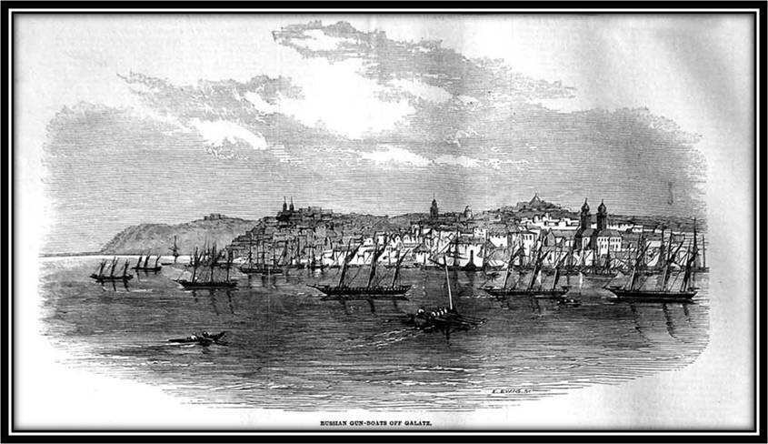
În ultimele secole faleza a evoluat sub influenţa factorilor naturali, abrupturile sale fiind erodate sub acţiunea apelor din precipitaţii sau apele subterane. Relatările despre aspectul falezei apar încă din secolul XVIII, călătorul Edouard Antoine Thouvenel scriacă ,,Am zărit Galaţiul din depărtare. Acest oraş se împarte în două părţi; oraşul nou ocupă o colină ridicată de unde privirea domină asupra Dunării şi a frumoşilor munţi", iar Georg Lauterrer continuă cu ,,…aşezat pe stânga, în Moldova, pe un dâmb foarte înalt şi abrupt.[1] Tot aspectul falezei este descris şi în Art. II – zona porto-franco, din 17.03.1837 ca ,, liniea mărgitoare porto-francului urmează începându-se din apa Dunării din sus spre mahalaua Râpile în zona dealului mare despre Tiglina şi de acolo de la mează zi către mează noapte prin hindicul acum făcut tot zarea dealului pe despre apus de şiruri de movile…..până la Dunăre în dreptul zării dealului de la malul mare".Într-o gravură ce i-a aparţinut lui Edmund Evans[2] şi care a fost publicată în 1853 în ziarul londonez Illustrated London News[3]sunt bine evidenţiate malurile abrupte ale Galaţiului, cu roca la zi, biserica din planul mai depărtat fiind Precista, iar în planul cel mai îndepărtat este dealul Țiglina.[4]
[1]E.A. Thouvenel - 1838, Georg Lauterrer – 1779, în ,, Oraşul Galaţi – în relatările călătorilor străini - 1848" [2]Era considerat un gravor celebru [3]Numărul din 19.11.1853 [4]Se pot observa dezvoltarea oraşului în partea joasă şi densitatea mare a corăbiilor din zona portului |
In the last centuries, the cliff has evolved under the influence of natural factors, its steepness being eroded under the action of rainwater or groundwater. Reports of the aspect of the cliff appear in the eighteenth century, traveller Edouard Antoine Thouvenel writing that We have seen Galaţi from afar. This city is divided into two parts; the new town occupies a high hill where the view dominates the Danube and the beautiful mountains and Georg Lauterrer continues ... set on the left in Moldova, on a very high and steep elevation[1]. The whole aspect of the cliff is also described in Art. II - the free port area, March 17, 1837, as the line of the free port follows the Danube water up to the slum called The ravines in the hill area towards Ţiglina and from there in the east towards the west through the recently created groove the outline of the hill westward towards the rows of mounds ... up to the Danube with the view of the hillside from the big cliff. In an engraving that belonged to Edmund Evans [2] and which was published in 1853 in the London newspaper Illustrated London News[3], the steep banks of Galaţi are well outlined, with Precista church in the background, farther afield being Ţiglina[4] hill.
[1] E.A. Thouvenel - 1838, Georg Lauterrer – 1779, in The City of Galaţi –foreign travellers’ notes-1848 [2] Considered a famous engraver [3] 19.11.1853 issue [4]The development of the city in the low part and the high density of ships in the port area can be seen. |
Gravură
Sursa: preluare de pe blogspot.ro – pagini de istorie a Galaţiului
Engraving Source: blogspot.ro – Galaţi history pages
Engraving Source: blogspot.ro – Galaţi history pages
|
Foarte mult timp malurile loessoide reprezentau un obstacol greu de trecut, ceea ce a şi dus la dezvoltarea oraşului mai mult în partea estică, unde înălţimea abruptului este mai mică. Spaţiile care astăzi sunt poziţionate în centru şi vestul oraşului nu erau atractive deoarece nu se puteau lega de Dunăre, abrupturile de 30-50 m fiind brăzdate de numeroase râpe la fel de abrupte.
|
For a long time, the loess banks were a difficult obstacle to overcome, which led to the development of the city predominantly in the eastern part, where the height of the cliff is smaller. The spaces that are located today in the center and the west of the city were not attractive because they could not connect to the Danube, the steepness of 30-50 m being covered by numerous ravines.
|
|
Mult mai târziu este modificată faleza spre sud şi sud-vest, respectiv partea dinspre Dunăre şi Siret. Influența antropicului asupra acestei porţiuni ai falezei debutează în anii 60, în strânsă legătură cu începuturile construcţiei combinatului siderurgic. Din fundaţia Laminorului de tablă groasă, construit pe platoul Smârdan, au fost scoase peste 1,5 milioane m3 de pământ (loess) cu care a fost amenajată zona falezei cuprinsă între valea Ţiglinei şi Palatul Navigaţiei, respectiv partea care este considerată Faleză a Dunării.[1] Materialul transportat din combinat a fost folosit la realizarea taluzului ce a acoperit tot malul abrupt, panta nouă apropiindu-se de 60%. Totodată au fost acoperite şi vechile râpe, hrube sau văi cu caracter sufozional, aspectul apropiindu-se de cel actual. Faleza a fost astfel consolidată şi structurată pe două benzi: pe faleza superioară s-a construit o arteră de circulaţie – Bulevardul Marii Uniri, iar în spaţiile în care erau localizate râpele, pe suprafaţa nou formată, au fost amenajate Grădina Botanică, Parcul Viva, Restaurantul Pescarul, iar în spate terenuri de tenis şi, în locul abruptului Bisericii Precista, o alee pietonală pe un vechi pârâu ce debuşa spre Dunăre. Faleza inferioară este amenajată în scop turistic, fiind pietonală destinată plimbărilor, bicicliştilor şi rolerilor. Legătura dintre cele două trepte ale falezei se face prin zone de acces situate de-a lungul ei, respectiv scări de 1,2m lăţime ce sunt amplasate pe taluz, la care se adaugă 3 scări betonate largi, placate cu traverin. Pe traseul Falezei poate fi urmărită expoziţia permanentă de sculpturi de metal, una dintre cele mai mari din estul Europei, realizată în anii 70 (au fost organizate șapte ediţii), cele mai multe dintre sculpturile realizate sunt localizate pe faleză, fiind rezultatul Taberelor Naţionale de sculptură din 1976, 1977 și 1991 – 24 de sculpturi.
[1]Conform unei alte definiţii DOOM, fâşie de teren amenajată pentru promenadă la baza unei faleze |
Much later, the south and southwest cliffs are modified, respectively towards the Danube and Siret. The manmade features on this part of the cliff are noticed in the 60's, in close connection with the beginnings of the construction of the steel mill. There were over 1.5 million m3 of loess excavated from the foundation of the heavy plate mill, built on the Smârdan Plateau, which were used to set up the area of the cliff between Ţiglina valley and the Navigation Palace, the part considered to be the Danube cliff[1]. The material transported from the steel mill was used to create the slope that covered the entire abrupt bank, the new slope approaching 60%. At the same time, the old ravines, caves or valleys created by infiltration were covered, the aspect approaching the current one (Fig. 5). The cliff was thus consolidated and structured on two lanes: a road was built on the upper cliff - the Unirii Boulevard, with the Botanical Garden, Viva Park, the Fisherman Restaurant built in the areas where the ravines were located, on the newly formed surface, with tennis courts at the back and, in place of the Precista Church cliff, they built a pedestrian alley on an old creek flowing to the Danube. The lower cliff is arranged for tourist purposes, being traffic free for promenade, cycling and rollerblading. The connection between the two steps of the cliff is made by access areas along it, i.e. 1.2 m wide stairs which are located on the slope, plus 3 large concrete stairs, covered with travertine. A permanent exhibition of metal sculptures, one of the largest in Eastern Europe, made in the 1970s (seven editions were organized) can be admired, most of the sculptures being located on the cliff, as a result of the National Sculpture Camps from 1976, 1977 and 1991 - 24 sculptures
[1] According to another DOOM definition, a strip of land set for the promenade at the base of a cliff |
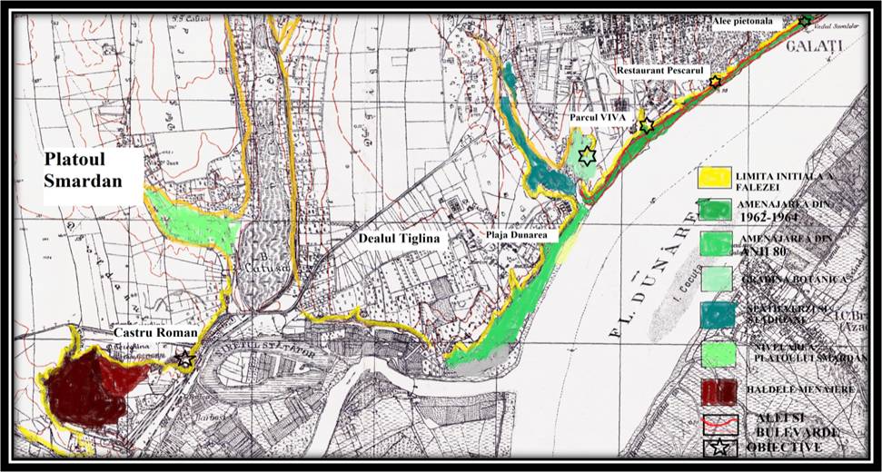
Modificările apărute până în 2017 în zona abruptului, faţă de 1941
Sursa: prelucrarea hărţii topografice din 1941
Changes occurred up to 2017 in the abrupt area, as opposed to 1941 Source: The modification of the topographic map of 1941
Changes occurred up to 2017 in the abrupt area, as opposed to 1941 Source: The modification of the topographic map of 1941
|
În anii ‘80 a fost amenajata faleza din apropierea confluenţei Dunării cu Siretul, pe măsură ce oraşul se extindea datorită creşterii demografice. Extremitatea falezei este amenajată prin realizarea unui taluz în 2 trepte, la baza cărora a fost construită o baza de agrement– parcuri, ştranduri şi plaje – plaja Dunărea, iar malul vestic, în zona cartierului Micro 20 este stabilizat cu ajutorul unor terase de beton, pentru a limita eroziunea. Efectele vizibile în transformarea falezei sunt evidente pe tot segmentul acesteia ce se află în paralel cu actualul curs al Dunării. De aceea malul abrupt al falezei este estompat de materialul cu care s-a realizat taluzul său, între anii 1962-1964, partea situată în aval de valea Ţiglinei şi la începutul anilor 80, partea situată în SV oraşului. Din acest motiv dominante sunt formele antropice de relief: terase utilizate pentru căi rutiere, excavaţiile au fost ocupate de stadioane, terenuri de tenis, lacul antropic din Grădina Botanică şi cascada din apropiere, bazine de înot. În cadrul lor sunt evidente procesele de tasare, cu afectarea covorului de asfalt, şiroire – rezultând mici rigole, prăbuşiri, fiind prezente trepte de alunecare superficiale. Acţiunea acestor procese este estompată de faptul că tot spaţiul este bine acoperit de vegetaţie arboricolă, arbustivă şi ierboasă.
|
In the 80's the cliff was set near the confluence of the Danube with the Siret as the city expanded due to demographic growth. The edge of the cliff is arranged by creating a two edge slope, with a recreational area at the base - parks, pools and beaches - the Danube beach, and the western bank in Micro 20 neighborhood is stabilized with concrete terraces, to limit erosion.
The effects of the transformation of the cliff are evident throughout its segment, which is parallel to the current Danube course. That is why the steep bank of the cliff is blurred by the material that made its slopes, the side downstream of Tiglina valley between 1962-1964 and, in the early 80's, the part situated in the south east of the city. For this reason, the manmade features of the landscape are dominant: terraces used for roads, excavations turned into stadiums, tennis courts, the manmade lake in the Botanical Garden and the nearby waterfall, swimming pools. Their process of compaction is visible with the damage to the asphalt layer, runoff - resulting in small gutters, collapses, superficial sliding steps. The action of these processes is blurred by the fact that all the space is well covered by arboreal, bushy and grassy vegetation. |


