The geological evolution of the cliff in the Quaternary
Loess[1] deposits in the south-east of the country are relatively recent and overlap on older sedimentary deposits disposed over the North-Dobrogean orogen. The Babele-Barboi strata (clay, sands) are deposited in the area between Siret and Prut in the first part of the Quaternary under the conditions of a transgression (Mindel-Riss) which drew the waters of the sea westwards of Galaţi, where they met with the Romanian Plain. Sedimentation also continues in the Pleistocene under the conditions of the E and NE restriction of the lake area, depositing alluviums, including those of the Danube. At the same time, a massive wind transport occurs through which the loess deposit resulted on the risen portions. It is said that the origin of the loess is Carpathian, the deposition period overlapping with the Gunz - Mindel interglacial, but especially Riss - Wurn, which explains the formation of a thick loess packet, which had as its source the rather extensive glacial deposits in the Carpathian region. The loess layer reaches 20-70 m in thickness, being located over a former piedmont plain, under the form of nearly smooth terraces, intercalating up to 7 horizons of fossil soils[2].
The subsidence[3] of the Lower Siret Plain started in the Upper Pleistocene, but its effects are observed during the Holocene, the descent being of 7-8 mm per year, also existing at present. The current area of the plain functioned as the last lake basin, sometimes linked to the Black Sea. It is visible through the appearance of a very low space between the towns of Galaţi and Brăila, where the disappearance of loess structures is clearly observable occurring both in the southern Glacis of Covurlui and in the north of Brăila Plain, at slightly lower altitudes.
The level oscillations of the Black Sea are the determining factors in the formation of steep slopes in Galaţi area. Many of the transgressions and marine regressions are controversial, in specialist books being hypotheses of these movements. There were transgressions that led to the penetration of the waters in the east of the Romanian Plain: the Karagat transgression (70000 years) led to the rise of the sea level by +10 m compared to the present level (Riss-Wurn interglacial). The last two transgressions in Holocene transformed the eastern area of the country into a bay, the sea waters increasing by 3 and 5 m above the current level, resulting in alluvia that led to a plowing of the courses of the Siret and Prut rivers, to the appearance of Cătuşa and Mălina lakes and the cutting of banks on the terrace fronts of the alluvial cones, resulting in the current cliff.
[1] Unconsolidated detritus sedimentary rock, predominantly dusty and porous composed of quartz, clay and carbonates.
[2] Posea 1987 – Physical geography;
[3]Subsidence - process of slow descent of the earth’s crust on its cracks / faults.
The evolution of the Danube course oscillates closely with the other three factors mentioned earlier, in Galaţi area deepening during the regression period or adding alluvia to the bed at transgression. Even though the sea waters have been increasing slightly over the past two millennia (about 4 m), after the last Holocene regression - the Fanagorian the formation of the Danube Delta begins, and the river course is maintained on the current route. However, the last regression causes a deepening of the Danube, which changes the base level and causes linear erosion in the loess deposits of the small tributaries that fragment the cliff giving it the lobe appearance - Ţiglina valley, Mălina or Cătuşa valleys, to which numerous infiltration valleys are added.
The geographical location of the cliff in the area of Galaţi
The city of Galaţi is located on 2 loess terraces ending in a steep shore to the east, south and west. The side parallel to the minor Danube bed is known as the Danube cliff, with a NE-SV orientation, with a slightly curved shape, convex towards the city. It is 4 km long, with a relative altitude that, in the highest parts, exceeds 40m.
The area located in the eastern part of the country is characterized by low altitudes, near the present mouths of the Danube flowing into the Black Sea. The low altitudes determined the area to be covered by water[1] over long periods of time, but the current landscape was modelled by the combined effects of several factors in the Quaternary: the loess deposits in the southern space of the Covurlui Glacis, the Black Sea level oscillations in the interglacial and glacial periods, the active subsidence in the Lower Siret Plain and, last but not least, the formation and evolution of the Danube valley. The combined effect of these factors led to the emergence of an inactive sinuous cliff that surrounds the city, in the area of Galaţi, in the shape of a peninsula with the basis to the north and similar to an open fan to the south. The cliff is a revealed abrupt modelled by wave erosion (abrasion) along the lake, sea and ocean shores, and which by its function can be active or dead[2]. A cliff is considered dead if the abrupt sectors created by marine abrasion are far away from the current shoreline position, where sea water does not reach at large storms. Such cliffs can be formed if epigenetic elevations occur in the area or, as it happened in the case of the cliff in Galaţi, sea regressions occur, which leads to the withdrawal of the sea; changing the base level determines the deepening of river systems - the Danube, in this case.
[1] Since the time of the Dacian basin (Pontian), the link with the Euxinic basin was made through the space where the city is located, thus functioning aquatic spaces – of the semi closed brackish type;
[2] According to the definition in the dictionary of physical geography– M. Ielenicz, 1999;
Climate aspects
The area where the cliff unfolds is located in temperate continental climate with arid features, where average temperatures of 10.5 ° C, dry, hot summers and cold, dry winters with blizzard phenomena are recorded.
In the cold season, when the air temperature drops a lot (-10, even -15°C) and the river water has positive temperatures of +2° or +3°C, there is a special phenomenon called The boiling Danube[1]. In the years when the water surfaces freezes, the pronounced cooling of the water will have an effect on the vegetation, in the spring the neighboring regions are colder, which is visible through the later flowering of the plants on the lakes and the Danube banks.
[1] In the winter, the temperature of the air can drop below zero degrees but the water temperature is still 1°C - 3°C above zero because the water has the highest specific heat (4185 J / kg K). The cooling of the water happens much more slowly than that of the air. Due to the temperature difference between the Danube water and the atmospheric air according to the cold wall principle, the water from the surface of the river vaporizes the phenomenon being known as the boiling Danube.


Hydrological aspects
The hydrological aspects are closely related to the evolution of aquatic systems. Most of the length of the cliff is quite far away from the water, so it is not directly affected. The only segment that comes more often into contact with the waters is the cliff located parallel to the current course of the Danube; at the increase of the flow from May to July the lower cliff is flooded by the river waters, the highest reached level being in 2010. (Fig. 5) Under these conditions infiltrations can undermine the stability of the cliff. The old valleys that flow into the Danube which are taken over by canals are very interesting but they have effects on the general stability. The so called Cliff-Hole used to be famous, a crumbling of the upper cliff in the space of the boulevard, in the area called La Elice, so that until September 2017, for 4 years, the traffic was diverted, considering that in addition to the groundwater that concentrates in that area, the shore is also hit by a Danube current as a result of the Siret discharge into the Danube, rebounding from the opposite river bank.
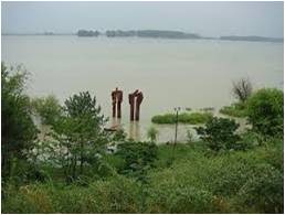
The sculpture Confluence – flooded by the Danube – in July 2010
Biopedogeographic aspects
The cliff has the appearance of woodland, regardless of the geographical position. Species that were initially aimed at increasing shore stability were planted. They have transformed over time into small woods (Fig. 6, 7, 8), stripes of greenery used for recreation. The dominant species are the acacia, linden, poplar, willow, near the water, ash, pine trees, to which shrub species are added.
The fauna is specific to the steppe - reptiles, snails, birds that build their nest in the loess shore; the cliff near the Danube was the habitat for a deer which arrived on the waterfront in the winter of 2012 when the river froze (Fig. 10 and 11), a hay feeding area was placed for its feeding; in winter, a family of long-eared owl (Fig. 9) settles here, and in the most forested area one can see pheasant families. The fish species are various, the waters being the field of carp, catfish, the Danube mackerel, etc.


